Louise Speaks: Day 40 Continued: In between some of the other sites of the day we covered some real quirky things…too quirky to pass up. I’m really going to miss blogging about these quirky things, because these have certainly been a fun part of the trip.
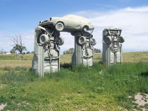
 Quirky spot #1 is Carhenge. Carhenge has been named the #2 Wackiest attraction in America. The only attraction deemed wackier than Carhenge is the toilet seat museum in San Antonio that features more than 800 decorated toilet seat lids but no bathroom. This is a replica of England’s famed Stonehenge. Carhenge uses old cars painted stone gray to replicate the stone formations found at Stonehenge.
Jim Reinders, experimented with unusual and interesting artistic creations throughout his life. While living in England, he had the opportunity to study the design and purpose of Stonehenge. His desire to copy Stonehenge in physical size and placement came to fruition in the summer of 1987 with the help of many family members. Thirty-eight automobiles were placed to assume the same proportions as Stonehenge with the circle measuring approximately 96 feet in diameter. Some autos are held upright in pits five feet deep, trunk end down, while those cars which are placed to form the arches have been welded in place. All are covered with gray spray paint. The honor of depicting the heel stone goes to a 1962 Caddy.
Carhenge was built as a memorial to Reinders’ father who once lived on the farm where Carhenge now stands. While relatives were gathered following the death of Reinders’ father in 1982, the discussion turned to a memorial and the idea of a Stonehenge replica was developed. The family agreed to gather in five years and build it. The clan, about 35 strong, gathered in June 1987 and went to work. They held the dedication on the Summer Solstice in 1987, with champagne, poetry, songs and a play written by the family. Carhenge has been preserved by a local group, who now owns and maintains it. Reinders donated the 10 acres of land where Carhenge is located. They have added a paved parking lot, picnic tables, and an educational display board. They even have a gift shop, where yes you can buy postcards and other unique items.
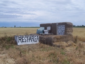
 Quirky Spot #2 is a Rest stop: Just about 5 miles from Carhenge is a unique rest stop. We actually found this spot on-line, under RoadSide America. It is hard to find although it is right on the main road. There is a platform built out of hay bales, to signify an open room. Inside the “room” is an old recliner and a Toilet. Someone has spray painted “rest stop” on the hay bales. If there would have been anyone else around, we would have had a picture taken of Thelma and I utilizing the Rest Stop. I know this is weird, but it did make us laugh.
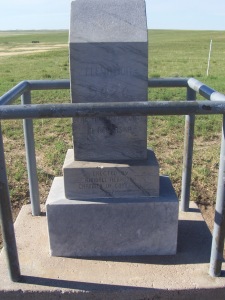
 Quirky Spot #3: Like I had mentioned in a previous blog, we found a brochure indicating that we were close to Nebraska’s Highest Point and the Tri State Marker. We first headed to find Nebraska’s Highest Point, What an adventure! We were told that this spot was in Kimball Nebraska. We arrived in Kimball and went to the last business at the edge of town, which was an auto supply store. They seemed a bit taken back but between three of them they directed us to what was supposed to be the highest point. Well you guessed it, we did not find it. We drove around this small town and found some people out in the yard. So we asked them if they knew where these spots were. We got the same reaction and they sent us over the freeway to another location. We took the road suggested and eventually it became a dirt road…of course a dirt road, but it wasn’t rough so off we went. Suddenly we saw a sign with an arrow that said “Highest Point “. Hooray, we were going the right way. So we followed the sign…for miles. We reached a dead-end, but there at least was another sign saying “Highest Point”. We followed the arrow and continued driving. By this time we have been looking for this Highest Point for about 2 hours. We were just about to give up when we spotted a truck. Now keep in mind we are in the middle of farm land with no buildings, no homes, no sign of life, so the truck was a welcome site. The truck happened to belong to the phone company. We asked him if he knew where the Highest Point was. He said yes and began giving us directions that included go right, go left, go around the curve, go left, go right and you should find it…oh boy! So since we had already invested over 2 hours to find this spot we thought what have we got to lose. So we tried to follow the phone mans instruction as best we could, but we had no idea if we were going the right way. After another hour, I told Thelma, lets forget it and go find the freeway. Just as we turned around we saw yet another sign that read “Highest Point” so of course we followed it , and we found it. It was actually a cement monument stating the sight and the height of 5,424 feet, which is pretty low concidering that Colorado is just next door. There was even a metal stand with a drawer asking people to sign their name and where they were from. I did this and also said, put up more signs, this was almost impossible to find. Since we had found this spot, we now had hope to find the Tri-State Marker spot.
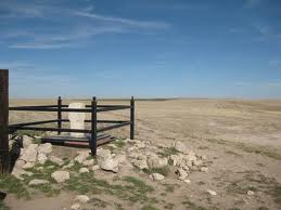
 Quirky Spot #4: We certainly didn’t plan on spending this much time looking for these two quirky spots. The Tri-State Marker was suppose to be very close to the Highest Point. The brochure showed a mountain but all we could see for miles and miles was flat land. There was not a mountain to be seen. We were still driving down these dirt roads, but now we were seeing farms here and there. We finally saw a farm that had a car and we stopped. I walked all around the house and various buildings, yelling “Hello–Hello”. Finally an old farmer came out of the barn and I asked him if he knew where the “Tri State Marker” was. He said, of course, and you’re real close. Well that was encouraging, and he began to give directions similar to that of the phone man. Then he said, wait, and he started drawing me a picture on the ground. It was very difficult for me to figure out what he was drawing, but if it was close I should be able to find it. I remember him saying go down the road, follow the curve, go over the cattle guard and it’s at a dead end…simple right? Wrong. We drove and drove and drove and drove…and we found nothing. Soon we cam to another farm-house, and we asked the same question. She told us it was just down the road but was very hard to see. That it was just a fence post with a marker. That is not what the brochure showed, but off we went. Again we drove and drove, we went back and forth looking at every fence post along the road, and still nothing. We went back to the same farm-house and asked was the fence post painted, is it different from the actual fences, and she said no, but it is hard to find. We tried again and still nothing. We were about to give up and headed to the freeway. On the way, we came upon a Bison Ranch and I told Thelma lets ask them and give this one more try. Remember we have now spent about 5 hours looking for these two spots, giving up now was not what we wanted to do. Jill at the Bison Ranch said we were not the first ones to come ask for directions. She said that the marker was on their property and if the Bison hadn’t been roaming free, we could have walked to the marker from the Highest Point monument. Instead of telling us, she took out paper and drew us a map. She told us the roads may be muddy so to be careful, and stay to the side. So off we went. As we turned on the road as Jill directed and there was the cattle guard as the farmer had told us. We drove down this road, and boy was Jill right, it was muddy, very very muddy. So muddy that we actually did a bit of a slide from side to side. We decided to stop and walk a bit, but saw no marker. It was disappointing to give up now, but we had no choice. We were close but yet far. Upon our return home, through many emails to the Bison organization, I found Jill’s email. I asked her if we were close, that we had driven as far as the windmill but the roads were too muddy. She answered me saying she did wonder if we’d be able to make it all the way…that the marker was at the end of the pasture, some ways past the windmill. She sent us a picture so we could have for our records.
What a day this was. Even in the Prius we used almost a tank of gas, close to 6 hours of time to find two of the quirkiest—most useless stops on our trip. We had planned to get past Wyoming for tonight and that was seeming not possible…but that is a whole new blog.
Other than the Carhenge this was a wasted day. Our main reason to see the Carhenge is because on this trip we had seen the TruckHenge, the BoatHenge, Cadillac Ranch and now the CarHenge…our Henge trip was now complete. Please, Please, Please do not bother to stop at any of these spots other than the Carhenge which is right in town and very easy to find. The rest, FORGET IT!!!
Thelma Speaks:
